
1. Overview
[ Interior Page] [Back to Structure Page] [Back to Main Page]
Overview
EMBARGOED UNTIL: 2:00 P.M. (EST) March 7, 1996
Photo No.: STScI-PRC96-09a
The never-before-seen surface of the distant planet Pluto is resolved in these NASA Hubble Space Telescope pictures, taken with the European Space Agency's (ESA) Faint Object Camera (FOC) aboard Hubble.
Discovered in 1930, Pluto has always appeared as nothing more than a dot of light in even the largest earth-based telescopes because Pluto's disk is much smaller than can be resolved from beneath the Earth's turbulent atmosphere. Pluto is 2/3 the size of Earth's Moon but 1,200 times farther away. Viewing surface detail is as difficult as trying to read the printing on a golf ball located thirty-three miles away!
Hubble imaged nearly the entire surface of Pluto, as it rotated through its 6.4-day period, in late June and early July 1994. These images, which were made in blue light, show that Pluto is an unusually complex object, with more large-scale contrast than any planet, except Earth.
Pluto itself probably shows even more contrast and perhaps sharper boundaries between light and dark areas than is shown here, but Hubble's resolution (just like early telescopic views of Mars) tends to blur edges and blend together small features sitting inside larger ones.
The two smaller inset pictures at the top are actual images from Hubble. North is up. Each square pixel (picture element) is more than 100 miles across. At this resolution, Hubble discerns roughly 12 major "regions" where the surface is either bright or dark.
The larger images (bottom) are from a global map constructed through computer image processing performed on the Hubble data. The tile pattern is an artifact of the image enhancement technique.
Opposite hemispheres of Pluto are seen in these two views. Some of the variations across Pluto's surface may be caused by topographic features such as basins, or fresh impact craters. However, most of the surface features unveiled by Hubble, including the prominent northern polar cap, are likely produced by the complex distribution of frosts that migrate across Pluto's surface with its orbital and seasonal cycles and chemical byproducts deposited out of Pluto's nitrogen-methane atmosphere.
The picture was taken in blue light when Pluto was at a distance of 3 billion miles from Earth.


This is the first image-based surface map of the solar system's most remote planet, Pluto. This map was assembled by computer image processing software from four separate images of Pluto's disk taken with the European Space Agency's (ESA) Faint Object Camera (FOC) aboard NASA's Hubble Space Telescope. Hubble imaged nearly the entire surface, as Pluto rotated on its axis in late June and early July 1994.
The map, which covers 85% of the planet's surface, confirms that Pluto has a dark equatorial belt and bright polar caps, as inferred from ground-based light curves obtained during the mutual eclipses that occurred between Pluto and its satellite Charon in the late 1980s.
The brightness variations in this map may be due to topographic features such as basins and fresh impact craters. However, most of the surface features unveiled by Hubble are likely produced by the complex distribution of frosts that migrate across Pluto's surface with its orbital and seasonal cycles. Names may later be proposed for some of the larger regions.
Image reconstruction techniques smooth out the coarse pixels in the four raw images to reveal major regions where the surface is either bright or dark. The black strip across the bottom corresponds to the region surrounding Pluto's south pole, which was pointed away from Earth when the observations were made, and could not be imaged.
Pluto itself probably shows even more contrast and perhaps sharper boundaries between light and dark areas than is shown here, but Hubble's resolution (just like early telescopic views of Mars) tends to blur edges and blend together small features sitting inside larger ones.
Pluto's surface brightness
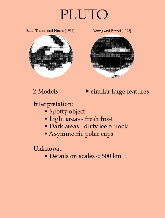 |
Several maps of Pluto's albedo (surface reflectivity) have been made based on the mutual event lightcurves. By keeping track of the decrease in brightness observed when part of Pluto is covered by Charon, we can solve for the brightness of the covered part. Eventually we can piece together a mosaic of Pluto's Charon-facing hemisphere. The two examples shown here are in surprisingly good agreement, considering they were based on separate data sets and independent algorithms. Both maps show a bright south polar region, which we now know to be nitrogen frost with a small fraction of methane in solid solution. The dark features have not been identified, although they may be colored by methane's photochemical by-products. (Buie, Tholen and Horne, Icarus, v.97, p.221, 1992; Young and Binzel, Icarus, v.102, p.134, 1993) |