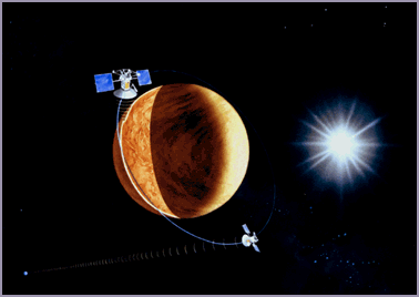
Magellan being deployed from Atlantis

Drawing of Magellan receiveing data and
transmitting back to Earth.
The Magellan space probe was launched from the space shuttle Atlantis on May 4, 1989. During its four years in orbit around Venus, Magellan acquired significant amounts of data. The orbits were classified into cycles of 243 days. This is equal to one Venutian day, and because Magellan followed a polar orbit, each cycle allowed the entire planet to fall beneath its radar. Magellan mapped Venus in 20 km strips using its synthetic - aperture radar (SAR). It produced radar images with a resolution of about 300 meters.
Magellan completed a total of five cycles, the first three were its radar imaging, and the last two were gravity data mapping. Magellan was also used to test the new technique of aerobraking. Aerobraking uses the atmosphere to direct or steer an aircraft and allow the atmosphere to help slow it down, rather than wasting rocket fuel to brake. This technique was used to bring Magellan into a closer, more circular orbit so that it could complete its last data cycle.
On October 12, 1994, Magellan plunged into Venus' swirling atmoshpere and was destroyed, crushed by Venus' intense pressure. Because it was known that Magellan would fail shortly because of an expired solar panel, it was decided that the orbiter would perform additional aerobraking experiments until its eventual demise into the Venutian atmosphere.


